INTERLIS Data exchange
This represents a guide on how to import/export data between TWW and INTERLIS 2 Transfer Format (XTF).
General
The TWW plugin includes an INTERLIS import/export feature. It is currently capable of importing and exporting the following models:
SIA405_ABWASSER_2020_1_LV95
DSS_2020_1_LV95
VSA_KEK_2020_1_LV95
SIA405_Base_Abwasser_1_LV95 (to export your own additional organisations that are not part of the centralized VSA Organisation dataset)
Note that currently, exports are possible in German only. Translated exports are on the roadmap, let us know if you are interested in this feature.
Prerequisites
Java
You need java on your system.
Windows : Java for windows download MacOS : Java for MacOS download Linux : use the package manager
Python libraries
You need sqlalchemy and geoalchemy2.
To install : before launching QGIS, open OSGeo4W Shell
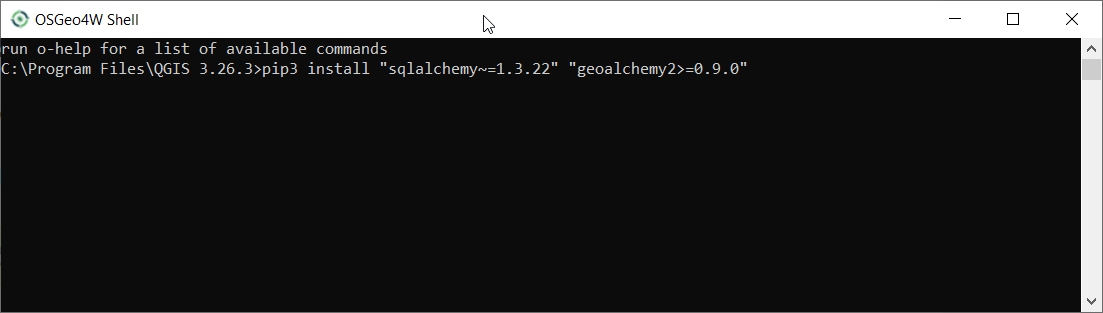
and type:
>>> pip3 install "sqlalchemy~=2.0.36" "geoalchemy2>=0.14.7"
If the command fails, try:
>>> pip3 install --upgrade pip
Note
If pip cannot be found, make sure you’ve installed the python3-pip package using the OSGeo4W network installer (if you’ve installed the standalone version of QGIS, it should be included).
If this command still fails, try:
>>> pip3 install --target=c:\somewhere\other\than\the\default --upgrade pip
where c:\somewhere\other\than\the\default is the path to your current pip package
The same –target flag can be added to install sqlalchemy and geoalchemy2 in another location.
TWW Version
The export only supports up-to-date TWW data model (2020.1 at the time of writing). Ensure your TWW data model is fully updated before trying to import/export.
Usage (GUI)
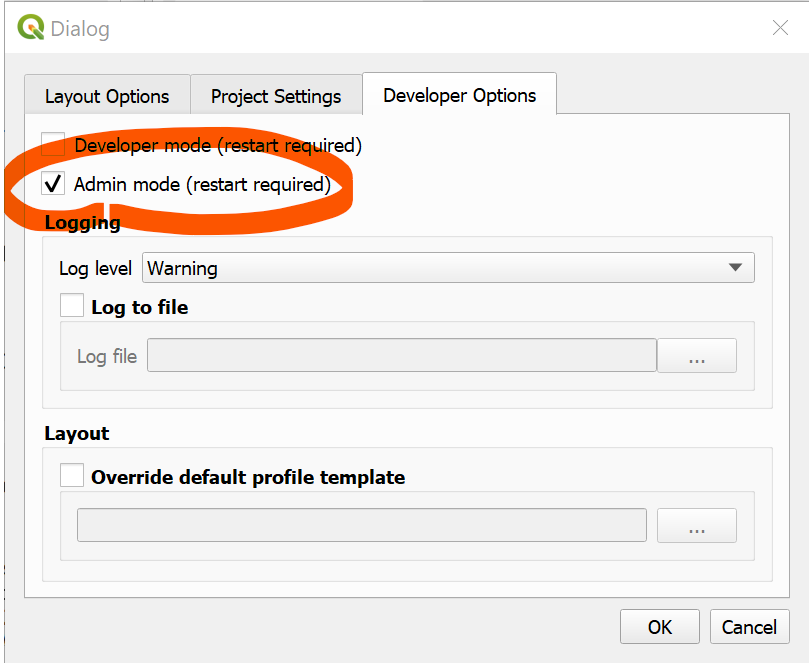
Enable admin mode
In the plugin>TWW>settings dialog, under the Developer options tab, ensure Admin mode is enabled. Restart QGIS.
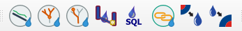
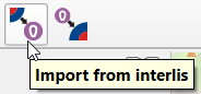
You should now see new import and export buttons in the TWW toolbar.
INTERLIS Export
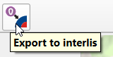
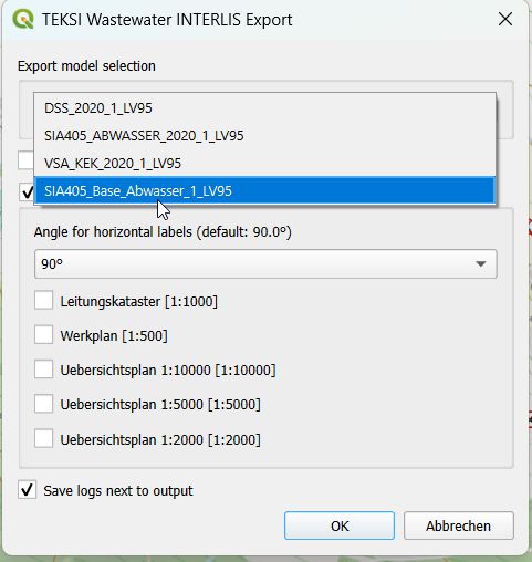
To export your TWW data, click on the INTERLIS export button.
The following dialog will appear.
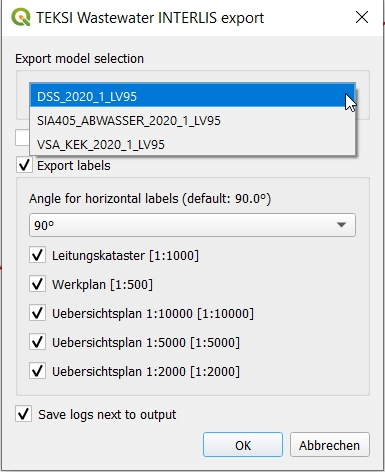
At first, select the export model.
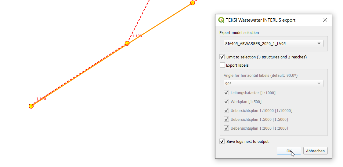
If you have an active selection in the nodes and/or reaches layer, you can choose to restrict the export to that selection. This is especially useful in combination with the upstream/downstream selection tools.
The export tools is capable of exporting label positions for different scales. You can choose which scales you are interested in exporting by selected/deselecting them.
Note
Only choose either Werkplan 1:500 or Werkplan 1:250. The latter may give you a more accurarte placement while printing labels in the scale 1:500. Choosing both scales will give you duplicate label positions - so avoid this! You will not be able to distinguish anymore which are the labels for 1:250 and 1:500 in the exported xtf file as both will get the plantype = “Werkplan” (currently VSA-DSS / SIA405 Abwasser 2020.x only supports one scale - this might change in a future release).
Then, confirm the dialog and choose where to save the .xtf file.
Note
Note that windows file pathes with empty strings in the directory path or filename are not supported at the moment.
Note
Note that for large/full exports, the command can take a long time.
Note
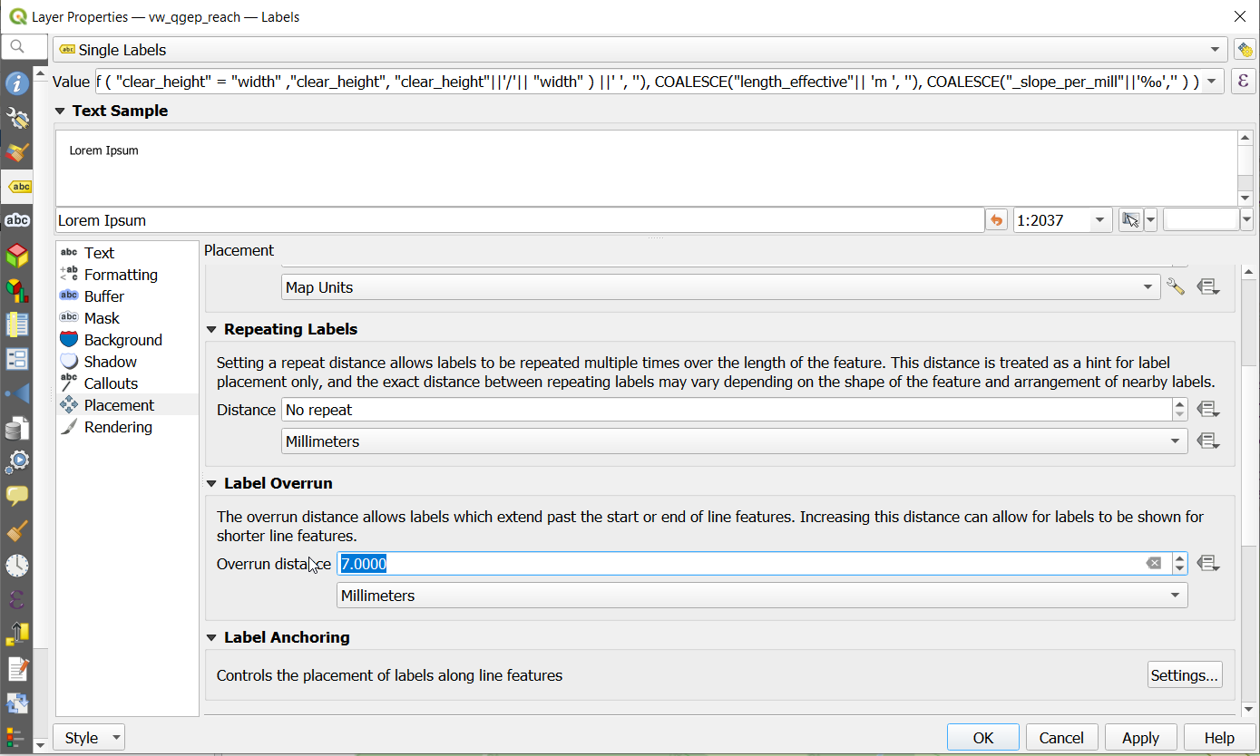
Note that QGIS standard behaviour for too long labels is to turn them horizontally (orientation = 0). You can adjust the properties of the vw_tww_reach layer - Symbology - Placement - Label overrun from “no overrun” to e.g. 7 mm (Millimeter)
Note
Note that remark fields are truncated to 80 characters on INTERLIS Export, as the INTERLIS definition is like this. If you have remark fields with more text then consider to move this data to documentation with the classes “file” and “data_media” so it can be exported to INTERLIS completely where you can add any document, photo or video to a class.
Note
More information on `QGIS label export https://docs.qgis.org/3.44/en/docs/user_manual/processing_algs/qgis/cartography.html#extract-labels`_
The following validations are run as pre-process:
Validate subclasses before export (_check_subclass_counts): The total of the subclass entries over alls subclasses must be equal to the numer of entries in the superclass.
Identifier NULL check (_check_identifier_null): As identifier is mandatory in the INTERLIS models, we check whether every identifier field has an entry (NOT NULL). If you have data, where you do not want to create your own identifiers, copy the obj_id as identifier (e.g. for reach_points). This is also the standard behaviour when you add new data. If you have copied data from elsewhere (not created in TEKSI), you might have to clean up this, else your INTERLIS export will stop.
Check references to the class organisation (_check_fk_owner_null, _check_fk_operator_null, _check_fk_dataowner_null, _check_fk_provider_null): Owner, Operator and the metainformation about dataowner and provider are MANDATORY in a INTERLIS Export file. Therefor these pre-checks make sure they are filled in. If you don’t know, choose the Organisation ‘unknown’, that is also an entry in the organisation dataset.
Check references to classes that are MANDATORY (e.g. _check_fk_reach_point_from_null, …): References that are MANDATORY in INTERLIS will be pre-checked to avoid crash during export.
You will get a new summary window that tells you, if any of these pre-checks failed:
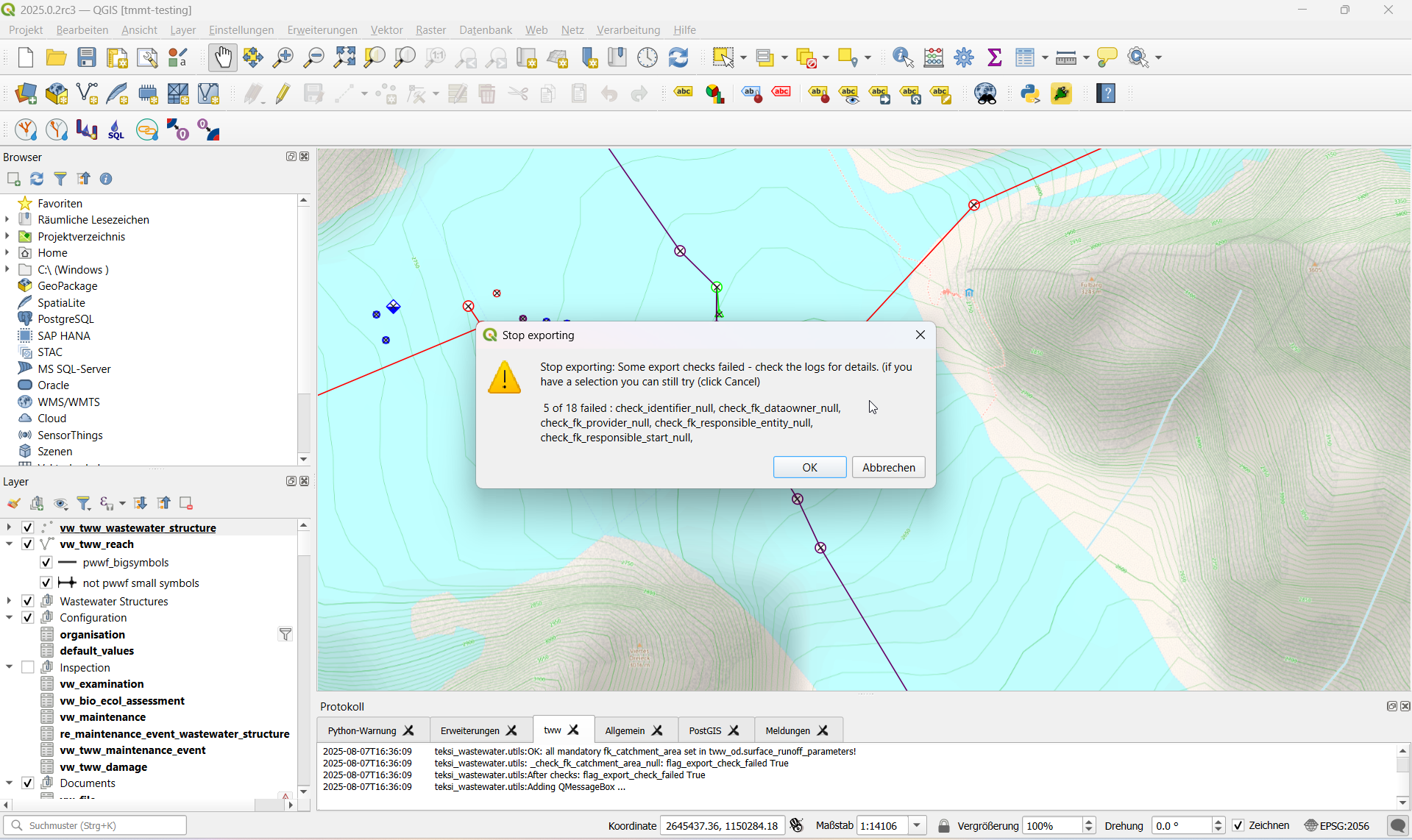
You can choose to continue export, if you think the pre-check results will not be relevant for your export (e.g. if you export SIA405 Abwaser, but there are reference check errors that are within the VSA-DSS part that are beyond SIA405 Abwasser).
Exports include also a validation step at the end using ilivalidator, which will inform you whether the export contains INTERLIS validation errors.
If the export was successful a green success message appears. If the export is not successfull you will get either error messages during the export process or an error warning at the end of the process.
You can check the protocol window and the text logs for further details.
Heading Export step |
Heading Description |
Heading Log File |
|---|---|---|
Export schema |
Creation of export schema with ili2db and the selected INTERLIS model file |
|
Data export intermediatary schema |
Export of data from tww_od to the new intermediary schema, translation from English to German |
*.tww2ili-export.log |
Data export to xtf |
Data export from intermediary schema to INTERLIS Transfer file (xtf) |
|
INTERLIS validation |
Validation of the created xtf file(s) with ilivalidator |
|
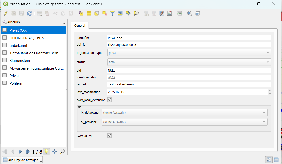
Export extra organisations
Since Release 2025.x you can also export additional organisations that are not maintained as part of the VSA organisation dataset and that you are maintaining yourself. For a general introduction on how organisation are maintained by the Verband Schweizer Abwasser & Gewässerschutzfachleute (VSA) check this documentation.
Extra organisations could be for example bigger private organisations that are ususally summarized as ‘Privat’ when publishing to others, but they are relevant for you to be distinguised. For an export they need to be flagged as tww_local_extension = True
INTERLIS Import
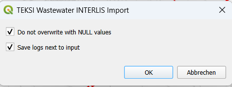
To import xtf`files, click on the `INTERLIS import button and navigate to the .xtf file.
Note
Note that windows file pathes with empty strings in the directory path or filename are not supported at the moment.
Note
There is a new option that you can avoid overwriting of data when there are NULL values of attributes in the import data set. This will keep your existing values that you already have in the database.
Organisations before data !
Note
Starting with release 2020 all organisations are in a separated dataset and need to be imported first, else a bunch of errors will be thrown on all references like fk_dataowner, fk_owner, fk_provider, etc. Download the VSA Organisation data set from https://www.vsa.ch/models/organisation/vsa_organisationen_2020_1.xtf and start with importing that data set. This data set is updated regularly - so please come back and check (and maybe re-import) at a later stage to have access to all available organisation.
If you have organisations that are not yet in that data set please inform the VSA and hand in an application to be added.
If you have additional own local organisations that are not (yet) in the VSA organisation data set continue with importing those before you start importing your network data. TV inspection data usually comes last, as it references your network data.
After launching the import process your data set will be validated and imported in a intermediatary schema. Then the following dialog will appear.
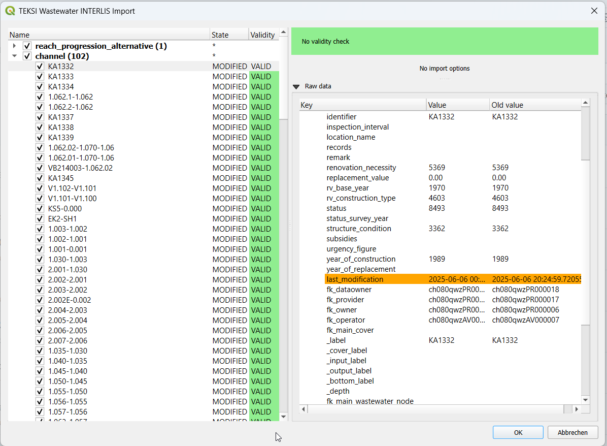
The left part of this dialog lists all elements that are going to be imported from the .xtf file, allowing to review what is going to be imported and to deselect elements you may want to skip. You can see, if there is already a dataset with the same obj_id in the state attribute: (EXISTING) means that the import will not change anything, (MODIFIED) tells you that some attributes have been changed. For details see on the right side, where you can compare the values for each attribute.
The second colums also shows the validation status of each object (VALID), showing whether further action is needed (INVALID) or recommended (WARNING) prior to importing.
The right part of this dialog shows a form specific to the type of element selected in the list, allowing to adapt the import.
Note
Currently de-selecting and selecting objects might take a long time depending how many data sets are in that respective class.
Once you’re happy with the import options, confirm the dialog to persist the changes to your database.
If the import was successful a green success message appears.
Usage (command line)
For advanced usage, the import/export tool can also be used as a command line tool.
Dependencies
The QGIS python classes must be available in the python interpreter.
On windows you can use the OSGeo4W environment
On linux you can extend the PYTHONPATH pointing to you QGIS installation, for example: export PYTHONPATH=”$PYTHONPATH:/usr/share/qgis/python”
Import
Import example
$ python3 plugin/tww_cmd.py interlis_import --xtf_file plugin/teksi_wastewater/tests/data/minimal-dataset-SIA405-ABWASSER.xtf --pgservice pg_tww
Full usage
$ python3 plugin/tww_cmd.py interlis_export --help

usage: tww_cmd.py interlis_export [-h] --xtf_file XTF_FILE [--selection SELECTION] [--export_model {SIA405_ABWASSER_2020_1_LV95,DSS_2020_1_LV95,VSA_KEK_2020_1_LV95}] [--logs_next_to_file]
                                               [--label_scale_pipeline_registry_1_1000] [--label_scale_network_plan_1_250] [--label_scale_network_plan_1_500] [--label_scale_overviewmap_1_10000] [--label_scale_overviewmap_1_5000]
                                               [--label_scale_overviewmap_1_2000] [--selected_ids SELECTED_IDS] [--pgservice PGSERVICE] [--pghost PGHOST] [--pgport PGPORT] [--pgdatabase PGDATABASE]
                                               [--pguser PGUSER] [--pgpass PGPASS]

options:
  -h, --help            show this help message and exit
  --xtf_file XTF_FILE   XTF outup file
  --selection SELECTION
                        if provided, limits the export to networkelements that are provided in the selection (comma separated list of ids)
  --export_model {SIA405_ABWASSER_2020_1_LV95,DSS_2020_1_LV95,VSA_KEK_2020_1_LV95}
                        Model to export (default: DSS_2020_1_LV95)
  --logs_next_to_file   Put log files next to XTF output file
  --label_scale_pipeline_registry_1_1000
                        Export labels in scale 1:1'000, can be combined with other scales (Leitungskataster/Cadastre des conduites souterraines)
  --label_scale_network_plan_1_250
                        Export labels in scale 1:250, should not be combined with other scales of Werkplan (Werkplan/Plan de reseau)
  --label_scale_network_plan_1_500
                        Export labels in scale 1:500, should not be combined with other scales of Werkplan (Werkplan/Plan de reseau)
  --label_scale_overviewmap_1_10000
                        Export labels in scale 1:10'000, can be combined with other scales (Uebersichtsplan/Plan d'ensemble)
  --label_scale_overviewmap_1_5000
                        Export labels in scale 1:5'000, can be combined with other scales (Uebersichtsplan/Plan d'ensemble)
  --label_scale_overviewmap_1_2000
                        Export labels in scale 1:2'000, can be combined with other scales (Uebersichtsplan/Plan d'ensemble)
  --selected_ids SELECTED_IDS
                        If provided, limits the export to networkelements that are provided in the selection (comma separated list of ids)
  --pgservice PGSERVICE
                        Postgres service name
  --pghost PGHOST       Postgres host
  --pgport PGPORT       Postgres port
  --pgdatabase PGDATABASE
                        Postgres database
  --pguser PGUSER       Postgres user
  --pgpass PGPASS       Postgres password
Export
Export example
python3 plugin/tww_cmd.py interlis_export --xtf_file "output.xtf" --pgservice pg_tww
Full usage
$ python3 plugin/tww_cmd.py interlis_export --help

usage: tww_cmd.py interlis_export [-h] --xtf_file XTF_FILE [--selection SELECTION] [--export_model {SIA405_ABWASSER_2020_1_LV95,DSS_2020_1_LV95,VSA_KEK_2020_1_LV95}] [--logs_next_to_file]
                                               [--label_scale_pipeline_registry_1_1000] [--label_scale_network_plan_1_250] [--label_scale_network_plan_1_500] [--label_scale_overviewmap_1_10000] [--label_scale_overviewmap_1_5000]
                                               [--label_scale_overviewmap_1_2000] [--selected_ids SELECTED_IDS] [--pgservice PGSERVICE] [--pghost PGHOST] [--pgport PGPORT] [--pgdatabase PGDATABASE]
                                               [--pguser PGUSER] [--pgpass PGPASS]

options:
  -h, --help            show this help message and exit
  --xtf_file XTF_FILE   XTF outup file
  --selection SELECTION
                        if provided, limits the export to networkelements that are provided in the selection (comma separated list of ids)
  --export_model {SIA405_ABWASSER_2020_1_LV95,DSS_2020_1_LV95,VSA_KEK_2020_1_LV95}
                        Model to export (default: DSS_2020_1_LV95)
  --logs_next_to_file   Put log files next to XTF output file
  --label_scale_pipeline_registry_1_1000
                        Export labels in scale 1:1'000, can be combined with other scales (Leitungskataster/Cadastre des conduites souterraines)
  --label_scale_network_plan_1_250
                        Export labels in scale 1:250, can be combined with other scales (Werkplan/Plan de reseau)
  --label_scale_network_plan_1_500
                        Export labels in scale 1:500, can be combined with other scales (Werkplan/Plan de reseau)
  --label_scale_overviewmap_1_10000
                        Export labels in scale 1:10'000, can be combined with other scales (Uebersichtsplan/Plan d'ensemble)
  --label_scale_overviewmap_1_5000
                        Export labels in scale 1:5'000, can be combined with other scales (Uebersichtsplan/Plan d'ensemble)
  --label_scale_overviewmap_1_2000
                        Export labels in scale 1:2'000, can be combined with other scales (Uebersichtsplan/Plan d'ensemble)
  --selected_ids SELECTED_IDS
                        If provided, limits the export to networkelements that are provided in the selection (comma separated list of ids)
  --pgservice PGSERVICE
                        Postgres service name
  --pghost PGHOST       Postgres host
  --pgport PGPORT       Postgres port
  --pgdatabase PGDATABASE
                        Postgres database
  --pguser PGUSER       Postgres user
  --pgpass PGPASS       Postgres password
Quality control
Quality control with VSA online checker (Fachprüfung mit VSA Checker (online))
