Layer Erläuterungen
Hauptlayer
TWW ist aufgebaut auf zwei Hauptlayer:
Abwasserbauwerke
tww_app.vw_tww_wastewater_structureHaltungen
tww_app.vw_tww_reach
Abwasserbauwerke tww_app.vw_tww_wastewater_structure
Haupt-Layer für Normschächte, Spezialbauwerke, Versickerungsanlagen, Einleitstellen (und ARA-Bauwerke). Wenn ein neuer Datensatz erstellt wird, wird immer ein neues Abwasserbauwerk, ein neuer Deckel und ein neuer Abwasserknoten erzeugt. In der Eingabemaske ist Zugang zu vielen verknüpften Tabellen (z.B. Bauwerksteile, Erhaltungsereignisse).
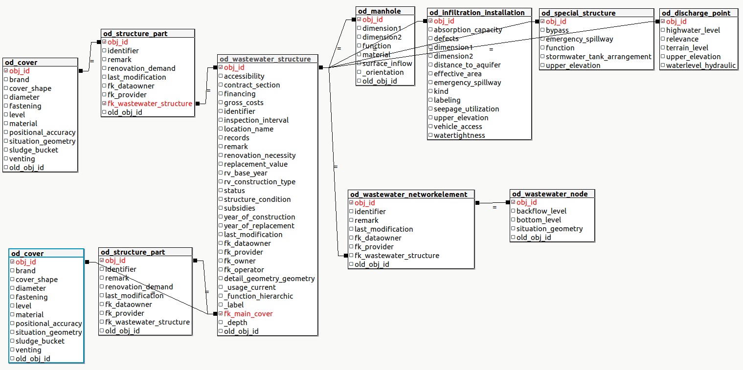
Auch wenn mehrere Deckel oder Abwasserknoten vorhanden sind, gibt es nur einen Punkt für ein Abwasserbauwerk in diesem Layer. Als Vorgabewert wird die Lage des ersten erzeugten Abwasserknotens verwendet.
Achtung
Diese Punkte können nicht als Deckel-Koordinaten exportiert werden. Benutze als Deckel den Layer vw_Deckel.
Geändert in Version 2025.0.
Das berechnete Feld tww_is_primary ist für eine benutzerdefinierte Definition der PAA Abwasserbauwerke vorhanden. Damit können Abfragen, Symbolisierungen und Beschriftungen einfacher definiert werden.
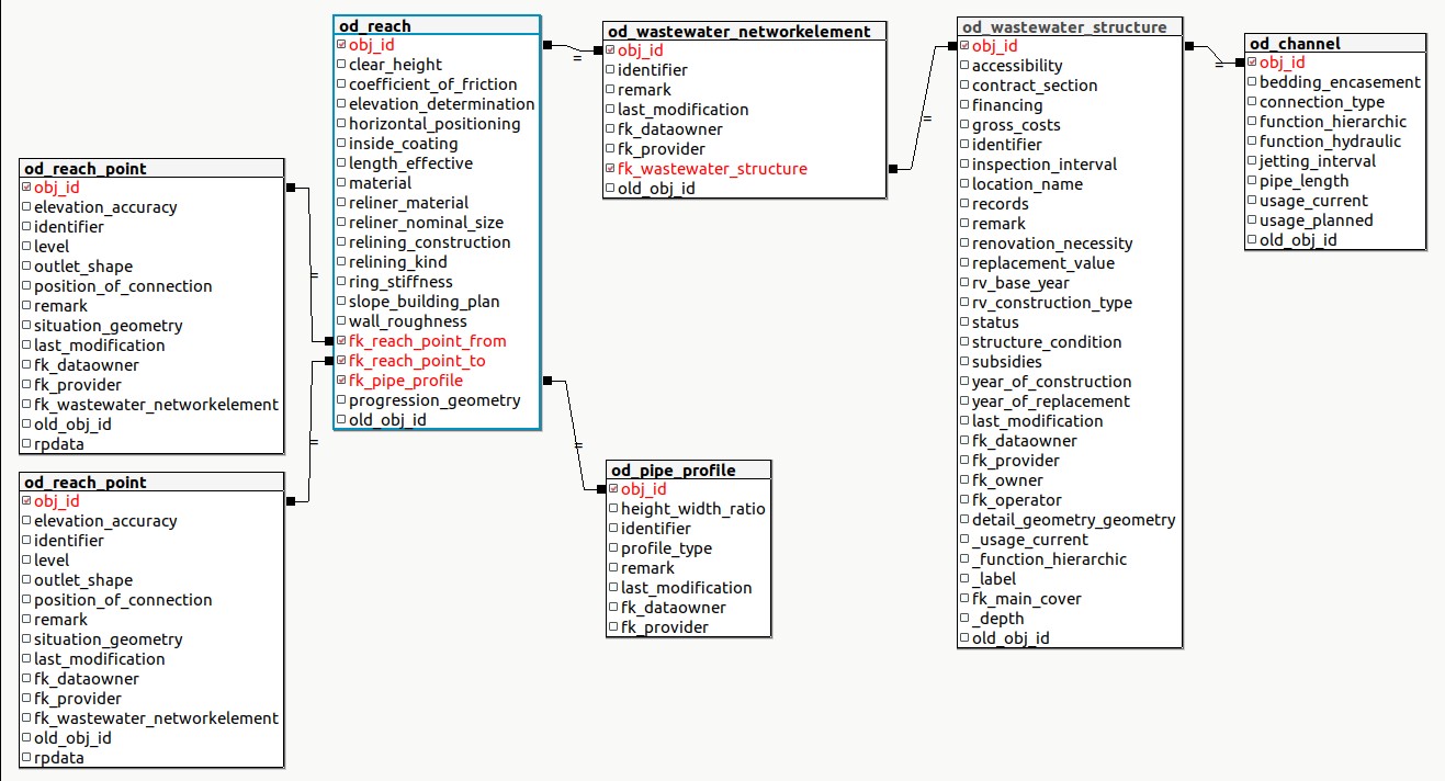
Haltungen tww_app.vw_tww_reach
Haupt-Layer für Linien-Abwasserbauwerke (Kanäle). Wird ein neuer Datensatz in diesem Layer erzeugt, wird eine neue Haltung und ein neuer Kanal erstellt. In der Eingabemaske ist Zugang zu vielen verknüpften Tabellen (z.B. Bauwerksteile, Erhaltungsereignisse).
Added in version 2025.0.
Das berechnete Feld
tww_is_primaryist für eine benutzerdefinierte Definition der PAA Abwasserbauwerke vorhanden. Damit können Abfragen, Symbolisierungen und Beschriftungen einfacher definiert werden.Erzeuge Spülstutzen auf Haltungen als Bauwerksteil von Kanälen
Layergruppe Abwasserbauwerke
Abwasserbauwerke Details tww_app.wastewater_structure
Diese Layer zeigen und ermöglichen das Editieren von Detailgeometrien von Abwasserbauwerken. Eine neue Detailgeometrie kann im Layer vw_tww_Abwasserbauwerk mit der Aktion Digitize erstellt werden.
Vergleiche Digitalisieren detaillierter Geometrie für weitere Infos.
Additional Wastewater Structures tww_app.vw_tww_additional_ws
Added in version 2025.0.
Ein Layer für die DSS-Klassen
Kleinkläranlage
Abflusslose Toilette
ARABauwerk
Bauwerksteile tww_app.structure_part
Geändert in Version 2025.0.
In der TWW Version 2025.X sind alle Bauwerksteile im TWW-Projekt konfiguriert. Weil es viele Bauwerksteil-Subklassen gibt sind sie in den Layergruppen Kanal-Bauwerkteil, Schacht-Bauwerksteil und DSS-mini-Bauwerksteil gruppiert.
Deckel und Spülstutzen sind die einzigen Bauwerksteile mit einer eigenen Lageinformation. Alle anderen Bauwerksteile sind nur mit ihrem Abwasserbauwerk verknüpft und sollen nur über die Hauptlayer (vw_tww_Abwasserbauwerk und vw_tww_Haltung) geändert werden.
Deckel tww_app.vw_cover
Den Deckellayer nur benutzen, um die Lageinfo von einem ausgewählten Deckel zu verändern (und nicht das ganze Abwasserbauwerk zu verschieben). Oder um einen neuen Deckel zu einem Abwasserbauwerk hinzu zufügen. (Ein Deckel kann auch im Reiter Deckel von vw_tww_Abwasserbauwerk hinzugefügt werden. Und der Layer wird verwendet, um die Position der Deckel darzustellen (z.B. im Werkplan) oder um die Deckellage zu exportieren.
Kanäle tww_app.mvw_tww_channel
Added in version 2025.0.
Die Klasse Kanal hat keine Geometrie. Mit mvw_tww_Kanal gibt es eine materialisierte View, die deshalb die Geometrie der Haltungen verwendet, um z.B. mit Erhaltungsereignissen zu arbeiten, die ja nicht mit Haltungen, aber mit Kanälen verknüpft sind.
Der „alte“`` vw_Kanal`` -Layer ohne Geometrie ist auch noch vorhanden.
Messstelle tww_od.measuring_point
Added in version 2025.0.
Nur der Layer Messstelle measuring_point (ein Teil des Subsystem Messung) ist vorhanden um die Attribute der Stammkarte Messstelle zu verwalten. Andere Tabellen des Substystem Messung sind in der Datenbank vorhanden, aber im QGIS-Projekt nicht konfiguriert.
Wechselpunkte tww_app.vw_change_points
Added in version 2025.0.
Eine View, um die Punkte mit Material-, Lichte-Hoehe oder Gefällswechsel darzustellen (Punkte müssen Abwasserknoten zwischen Haltungen mit dem gleichen Kanal sein).
Layergroup Configuration
Organisationen tww_od.organisation
Table organisation contains the organisations that you can select in attributes like fk_dataowner, fk_operator, fk_provider, fk_owner, etc.
Import the VSA organisation 2020.1-dataset that contains over 2’500 organisations. And/or create project-specific organisations, which, however, must be imported and exported additionally with every data exchange.
In order to use the organisations efficiently, one can flag an organisation as active using the field tww_active. This flag filters the organisations accessible from the QGIS project.
Layergruppe Untersuchung-Unterhalt
Added in version 2025.0.
Die Layer tww_app.vw_tww_channel_maintenance und``tww_app.vw_tww_ws_maintenance`` nutzen die Geomtrie und die wichtigsten Attribute der verknüpften Abwasserbauwerke um Erhaltungsereignisse in der Karte darzustellen. In diesen Layern können nicht neue Erhaltungsereignis-Datensätze erfasst, aber es können Felder geändert werden und es kann symbolisiert und exportiert werden.
Erhaltungsereignis tww_app.vw_tww_maintenance_event
Erhaltungsereignisse können mit der View tww_app.vw_tww_maintenance erstellt werden.
Die Erhaltungsereignisse werden im Tab Erhaltungsereignis in den Hauptlayern benutzt. Erhaltungsereignisse können mit einem oder mehreren Abwasserbauwerken verknüpft sein.
Vergleiche Bearbeiten von Erhaltungsereignissen für mehr Infos.
Biol_oekol_Gesamtbeurteilung tww_app.vw_bio_ecol_assessment
Added in version 2025.0.
Eine Subklasse der Erhaltungsereignisse
Erstellen Sie die biol_oeko_Gesmatbeurteilungen in den Haupttabellen (Einleitstellen in vw_tww_Abwasserbauwerk) und visualisieren Sie sie in vw_tww_ws_maintenance.
Dokumente
Geändert in Version 2025.0.
Dokumente sind jetzt in einer eigenen Layergruppe (vorher in der Layergruppe Abwasserbauwerke)
Hydraulik Layer
Abwasserknoten tww_app.vw_wastewater_node
Dieser Layer kann nur benutzt werden, wenn nur ein ausgewählter Abwasserknoten in der Lage geändert werden soll (und nicht das ganze Abwasserbauwerk) oder wenn ein neuer Abwasserknoten zu einem bestehenden Abwasserbauwerk hinzugefügt werden soll. Ein Abwasserknoten kann auch im Reiter Abwasserknoten der vw_tww_Abwasserbauwerk-Eingabemaske hinzugefügt werden. Beim Verschieben der Geometrie des Abwasserknotens wird die Geometrie der angeschlossenen Haltungen automatisch aktualisiert. Wenn Sie einen Abwasserknoten verschieben möchten, ohne die Haltungen zu verschieben, trennen Sie die Haltungen , verschieben Sie den Knoten und verbinden Sie die Haltungen anschließend wieder.
Überlauf Tabellen tww_app.vw_tww_overflow
Verwenden Sie diesen Layer, um Überläufe zu erstellen und zu symbolisieren.
Layergruppen Einzelobjekt, Massnahmen, Stammkarte, Abwasserentsorgung im ländlichen Raum
Added in version 2025.0.
Weil diese Klassen in der DSS Version 2015 noch nicht vorhanden waren, waren sie in TEKSI Abwasser Version 2024 noch nicht konfiguriert.
Alle DSS-Klassen sind jetzt in TWW konfiguriert.
Einzugsgebiet tww_app.vw_tww_catchment_area
Hauptlayer zum Digitalisieren und Bearbeiten der Einzugsgebiete. Die Layer „Einzugsgebietsverbindungslinien“ visualisieren lediglich die Verbindungen und sind nicht editierbar.
Geändert in Version 2025.0.
Die FS-Felder für die Verknüpfung mit den Stammkarten sind jetzt konfiguriert.
Topologie
Punkte tww_app.vw_network.node und Linien tww_app.vw_network.segment
Diese beiden Layer werden von TWW für die Netzverfolgung verwendet. Nicht verändern. Der Layer vw_network_segment kann benutzt werden, um die Fliessrichtung darzustellen. Dazu kann als Symbol eine Marker-Linie (filled_arrowhead) verwendet werden.
Vergleiche Werkzeuge zur Netzwerkverfolgung für mehr Infos und wie eine zweckmässige Topologie erstellt und gepflegt werden soll.
Wertelisten tww_vl.*
These value lists are defined in the VSA-datamodel.
Warnung
Do not change!
Geändert in Version 2025.0.
Abwasserentsorgung im ländlichen Raum
Dieses Thema umfasst die Klassen zur Abwasserentsorgung in ländlichen Raum außerhalb der Bauzone.
Added in version 2025.0.
Gebäudegruppe tww_od.building_group
Gebäude oder Gebäudegruppen in ländlichen Gebieten, die sich außerhalb des Baugebiets befinden und landwirtschaftliche Betriebe (einschließlich derjenigen, die sich in den Bauzonen befinden).
Landwirtschaftsbetrieb tww_od.farm
Landwirtschaftlicher Betrieb (Bauernhof): Muss ebenfalls innerhalb des Abwassereinzugsgebiets angegeben werden (d.h. auch dann, wenn sich der Betrieb innerhalb der Teileinzugsgebiete des Allgemeinen Entwässerungsplans (GEP) befindet).
Entsorgung tww_od.disposal
Informationen zur Abwasserentsorgung aus Gebäudekomplexen (Behandlung/Schlammentsorgung)
Gebäudegruppe_BAUGWR tww_od.building_group_baugwr
Zwischentabelle zur Auflösung der n-n-Beziehung zwischen Gebäudegruppen und Gebäudedetails (in BAU/GWR)
re_building_group_disposal tww_od.re_building_group_disposal
Beziehungstabelle für die n:m-Beziehung zwischen Gebäudegruppe und Entsorgung
Stammkarte
Added in version 2025.0.
Stammkarte tww_app.vw_tww_log_card
Log card for special structures: Hydraulically specialized wastewater structures, e.g., storm water basins, storm water overflows, or pumping stations. Most special structures are also specialized structures. However, special structures such as separation structures or small pumping stations are often designed as manholes.
Gesamteinzugsgebiet tww_app.catchment_area_totals
Informationen zum zugehörigen Einzugsgebietsflächen (Total), den Wassermengen und dem Einleitstellen des Regenüberlaufs bzw. des Regenbeckens. Die direkte Einzugsgebietfläche muss nur angegeben werden, wenn der Überlauf während des Bemessungsereignisses anspringt oder wenn das Anspringen unsicher ist. Alle Angaben müssen für den Ist- und den Planungszustand gemacht werden. Die Eingabe aller Informationen erfolgt manuell (Version 2025.02).
tww_app.vw_catchment_area_totals basiert auf der Materialized view tww_app.mvw_catchment_area_totals.
tww_app.mvw_catchment_area_totals fasst die Flächen der Einzugsgebiete pro Stammkarte zusammen.
tww_app.vw_catchment_area_totals fügt die Werte von tww_od.catchment_area_totals und tww_app.hydr_char_data zu den zusammengefassten Einzugsgebieten hinzu
Zusammengefasste Gesamteinzugsgebiete tww_app.vw_catchment_area_totals_aggregated
Nicht zu verwechseln mit tww_app.vw_catchment_area_totals.
Diese View fasst eine Reihe von Werten aus den Einzugsgebieten zusammen und schließt dabei fallweise auch Einzugsgebiete von vorherigen Stammkarten ein.
Einwohner summiert auch die Werte der oberliegenden Stammkarten
Flaeche summiert nur die direkt angeschlossenen
Flaeche_Bef summiert nur die direkt angeschlossenen
Flaeche_red summiert nur die direkt angeschlossenen
Fremdwasseranfall summiert auch die Werte der oberliegenden Stammkarten
Schmutzwasseranfall summiert auch die Werte der oberliegenden Stammkarten
resp. die _dim Werte
Beide Views ordnen catchment_area und log_card wie folgt zu:
[catchment_area.fk_special_building_xx_yy] - > (log_card.obj_id)
[log_card..fk_main_structure] - > (log_card.obj_id) --optional
[log_card.fk_pwwf_wastewater_node] - > (wastewater_node.obj_id)
(wastewater_node.obj_id) <- [hydr_char_data.fk_pwwf_wastewater_node] -- with status=current
(hydr_char_data.obj_id) <- [catchment_area_totals.fk_hydr_char_data]
Hydr Kennwerte tww_od.hydraulic_char_data
Aggregierte Hydr_Kennwerte