Explication des couches
Couches principales
TWW est construit autour de deux couches principales :
Les ouvrages d’assainissement
tww_app.vw_tww_wastewater_structureLes tronçons
tww_app.vw_tww_reach
Les ouvrages d’assainissement tww_app.vw_tww_wastewater_structure
Couche principale pour les ouvrages standards, installations spéciales, installations d’infiltration, exutoires (et stations d’épurations des eaux (STEP)). Créer une nouvelle entité dans cette couche crée toujours une nouvelle structure d’assainissement, un nouveau couvercle et un nouveau noeud réseau. Dans le formulaire d’édition, vous avez accès aux tables liées (ex. parties de structures, évènements de maintenance)
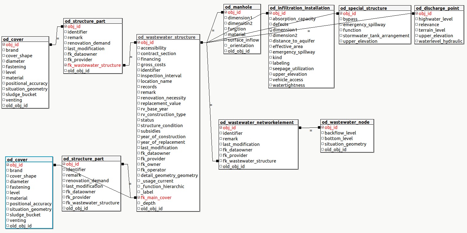
Même si un ouvrage est composé de plusieurs couvercles et nœuds réseaux, un seul point par ouvrage est représenté au sein de cette couche. Par défaut, la position du premier nœud réseau est utilisée comme coordonnées pour ce point.
Attention
Ne pas exporter les coordonnées de ces points comme couvercles. Utiliser la couche vw_cover pour cela.
Modifié dans la version 2025.0.
A calculated field tww_is_primary is available for the user-defined definition of primary wastewater structures. It allows easier definitions of queries, symbologies and labels.
Les tronçons tww_app.vw_tww_reach
Couche principale pour les ouvrages linéaires d’assainissement (canalisations). Créer une nouvelle entité dans cette couche crée toujours un nouveau tronçon et une nouvelle canalisation. Dans le formulaire d’édition, vous avez accès aux tables liées (ex. parties de structures, évènements de maintenance, fichiers)
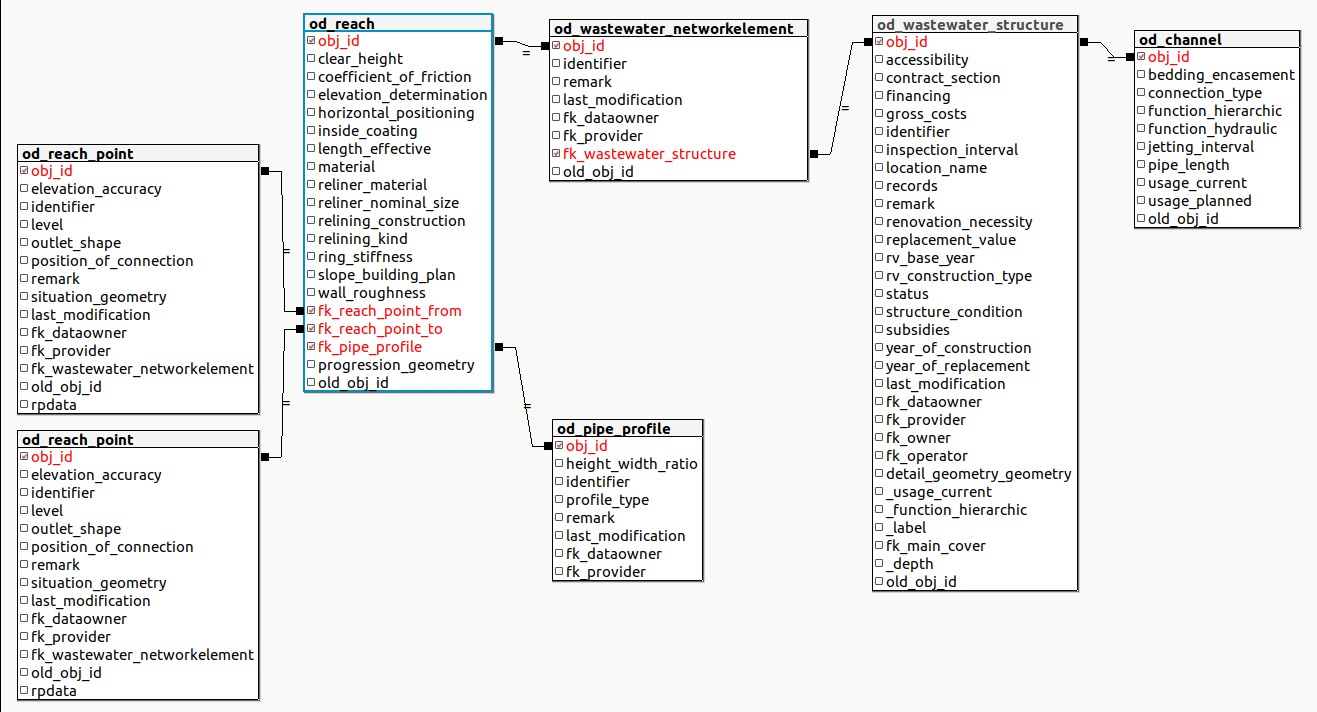
Ajouté dans la version 2025.0.
A calculated field
tww_is_primaryis available for the user-defined definition of primary wastewater structures. It allows easier definitions of queries, symbologies and labels.Create flushing_nozzle on reaches as structure part of the channel.
Layergroup Wastewater Structures
Détails d’ouvrages d’assainissement tww_od.wastewater_structure
Cette couche permet de visualiser et d’éditer les détails de géométrie des ouvrages d’assainissement. Il est possible de digitaliser une nouvelle géométrie de détail en utilisation l’action digitize detailed geometry de la couche vw_tww_wastewater_structure.
Voir digitalisation des géométries de détail pour plus d’informations.
Additional Wastewater Structures tww_app.vw_tww_additional_ws
Ajouté dans la version 2025.0.
A layer for the DSS-classes
small_treatment_plant
drainless_toilet
wwtp_structure
Parties d’ouvrages tww_od.structure_part
Modifié dans la version 2025.0.
In version 2025.0 are all structure_parts configured in the TWW-project. Because there are many structure parts, they are grouped in layergroups Structure Parts Channel, Structure Parts Manhole and DSSMini Structure Parts.
Cover and flushing nozzle are the only structure parts with a point-geometry itself. All other structure parts are just linked to their wastewater structures and should by only edited by the main layers (vw_tww_wastewater_structure and vw_tww_reach).
Couvercles tww_app.vw_cover
Use this layer to change the situation of some specific cover (and not the whole wastewater structure) or to add a new cover to an existing wastewater structure. You can add an additional covers in the covers-tab of the vw_tww_wastewater_structure too. Additionally, use this layer to show the detailed position of the covers (e.g. in network_plan or pipeline_registry) or to export the cover positions situation_geometry.
Channels tww_app.mvw_tww_channel
Ajouté dans la version 2025.0.
The channel-class has no geometry. Therefore, mvw_tww_channel is a materialized view that uses the reach line-geometries to work with e.g maintenace_events, that are not connected to reaches, but to channels.
The « old » vw_channel -layer without geometry still exits beside.
Measuring_point tww_od.measuring_point
Ajouté dans la version 2025.0.
Just the layermeasuring_point (as part of the measuring subsystem) is added to be able to attribute the measuring_point-log-cards. Other tables of the measuring subsystem are available in the database, but are not configured.
Change Points tww_app.vw_change_points
Ajouté dans la version 2025.0.
A view to visualize the points (wastewater_nodes between to reaches of the same channel), where material or clear_heigth or slope changes.
Layergroup Configuration
Organisations tww_od.organisation
Table organisation contains the organisations that you can select in attributes like fk_dataowner, fk_operator, fk_provider, fk_owner, etc.
Import the VSA organisation 2020.1-dataset that contains over 2’500 organisations. And/or create project-specific organisations, which, however, must be imported and exported additionally with every data exchange.
In order to use the organisations efficiently, one can flag an organisation as active using the field tww_active. This flag filters the organisations accessible from the QGIS project.
Layergroup Examination-Maintenance
Ajouté dans la version 2025.0.
Visualized maintenance-events with the layers tww_app.vw_tww_channel_maintenance and tww_app.vw_tww_ws_maintenance that adds the geometry and the most important attributes of the connected wastewater_structures to the maintenance_event-records.
You can not create new maintenance-events with this views, but you can edit attributes, symbolize and export
Evénements de maintenance``tww_app.vw_tww_maintenance``
Maintenance events can be created through the view tww_app.vw_tww_maintenance.
Ces événements de maintenance sont utilisé dans l’onglet maintenance des tables principales. Ils peuvent être liés à un ou plusieurs ouvrages.
Voir Edition des événements de maintenance pour plus d’information.
Bio_Ecol_Assessment tww_app.vw_bio_ecol_assessment
Ajouté dans la version 2025.0.
A subclass of Maintenance_event
Create the bio_ecol_assessments in the main tables (discharge points in vw_tww_wastewater_structure) and visualize it in vw_tww_ws_maintenance.
Documents
Modifié dans la version 2025.0.
Documents have now there own layergroup (before in layergroup Wastewater Structures)
Hydraulique
Wastewater nodes tww_app.vw_tww_wastewater_node
Use this layer to change the situation of one selected wastewater node (and not the whole wastewater structure) or if you want to add a new wastewater node to an existing wastewater structure. You can add additional wastewater nodes in the wastewater nodes-tab of the vw_tww_wastewater_structure too. When moving the geometry of the wastewater node, the geometry of the connected reaches is updated automatically. If you want to move a wastewater node without moving the reaches, disconnect the reaches, move the node and reconnect the reaches.
Overflow tables tww_app.vw_tww_overflow
Use this layer to create and symbolize overflows.
Layergroups Connection Object, Measures, Log Card, Rural
Ajouté dans la version 2025.0.
Since these layers where not available in DSS 2015, they have not been in the tww version 2024.
All DSS-tables are now configured in TWW.
Catchment tww_app.vw_tww_catchment_area
Main layer to digitize and edit the catchment_areas. Layers catchment_connection lines do just visualize the connections. They are not editable.
Modifié dans la version 2025.0.
The fk-fields to connect to the log cards are know configured.
Topologie
Nodes tww_app.vw_network_node and segments tww_app.vw_network_segment
These two layers are used by the tww-extension for the network-following functionalities. Use the vw_network_segment layer to show the flow direction, if you use a markerline (filled_arrowhead) as symbol.
See connect wastewater network elements for more information on how to create and maintain a good topology.
Listes de valeurs tww_vl.*
These value lists are defined in the VSA-datamodel.
Avertissement
Do not change!
Modifié dans la version 2025.0.
Rural
This topic covers the classes related to waste water disposal in rural areas that are located outside the sewerage area.
Ajouté dans la version 2025.0.
Building group tww_od.building_group
Buildings or groups of buildings in rural areas that are located outside the sewerage area, as well as buildings belonging to agricultural businesses (including those within the sewerage area)
Farm tww_od.farm
Agricultural business (farm): Must also be specified within the sewerage area (i.e. even if the business is located within the sub-catchment areas of the General Drainage Plan (GEP)).
Disposal tww_od.disposal
Information on the disposal of wastewater from building complexes (treatment/sludge disposal)
Building_group_BAUGWR tww_od.building_group_baugwr
Intermediate table for resolving the n-n relationship between building groups and building details (in BAU/GWR)
re_building_group_disposal tww_od.re_building_group_disposal
Relationship table for n:m relationship between building_group and disposal
Log card
Ajouté dans la version 2025.0.
Log card tww_app.vw_tww_log_card
Log card for special structures: Hydraulically specialized wastewater structures, e.g., storm water basins, storm water overflows, or pumping stations. Most special structures are also specialized structures. However, special structures such as separation structures or small pumping stations are often designed as manholes.
Catchment area totals tww_app.catchment_area_totals
Information on the attached catchment area (total), water volumes, and discharge point of the storm overflow or storm overflow basin. Direct catchment area only needs to be filled in if the discharge is activated during the design event or if it is unknown whether it will be activated. All information must be provided for both the actual and planned status. All information must be provided manually (Version 2025.02).
tww_app.vw_catchment_area_totals is based on the materialized view tww_app.mvw_catchment_area_totals.
tww_app.mvw_catchment_area_totals aggregates the geometry of the catchment areas by log card.
tww_app.vw_catchment_area_totals adds the values of tww_od.catchment_area_totals and tww_app.hydr_char_data to the aggregated geometries
Catchment area totals aggregated tww_app.vw_catchment_area_totals_aggregated
It is not to be confused with tww_app.vw_catchment_area_totals.
This view aggregates a set of values from the catchment areas, sometime including catchment areas on previous log cards
population includes upstream log cards
surface_area includes direct only
surface_imp includes direct only
surface_red includes direct only
sewer_infiltration_water includes upstream log cards
waste_water_production includes upstream log cards
_dim values respectively
Both views map catchment_area and log_card via the following procedure:
[catchment_area.fk_special_building_xx_yy] - > (log_card.obj_id)
[log_card..fk_main_structure] - > (log_card.obj_id) --optional
[log_card.fk_pwwf_wastewater_node] - > (wastewater_node.obj_id)
(wastewater_node.obj_id) <- [hydr_char_data.fk_pwwf_wastewater_node] -- with status=current
(hydr_char_data.obj_id) <- [catchment_area_totals.fk_hydr_char_data]
Hydraulic char data tww_od.hydraulic_char_data
Aggregated hydraulic characteristics